Sunday 11 September 2011

3. Nature’s Fury: the Site of Tiharkhera on Way to Extinction

About 3.5 km to the south of Fatehganj west, on the left bank of river Bahgool or Dojora (a major tributary of the river Ramganga), in District Bareilly, is situated the extensive mound of Tiharkhera (28026 09” N: 7901722’’ E). The site is located about 5km northwest of the site of Gokalpur and 16km northeast of Ahichhatra as the crow flies. The mound stands majestically to a height of 11m above the river basin and presently spreads over an area of 12 acres. It could have been double the size of that we see today. The site has been a natural embankment for the village and protecting from the catastrophic flood of the river.
1. Site of Tiharkhera+R. Bahgool- 2005
2.Site of Tiharkhera+R. Bahgool- 2009
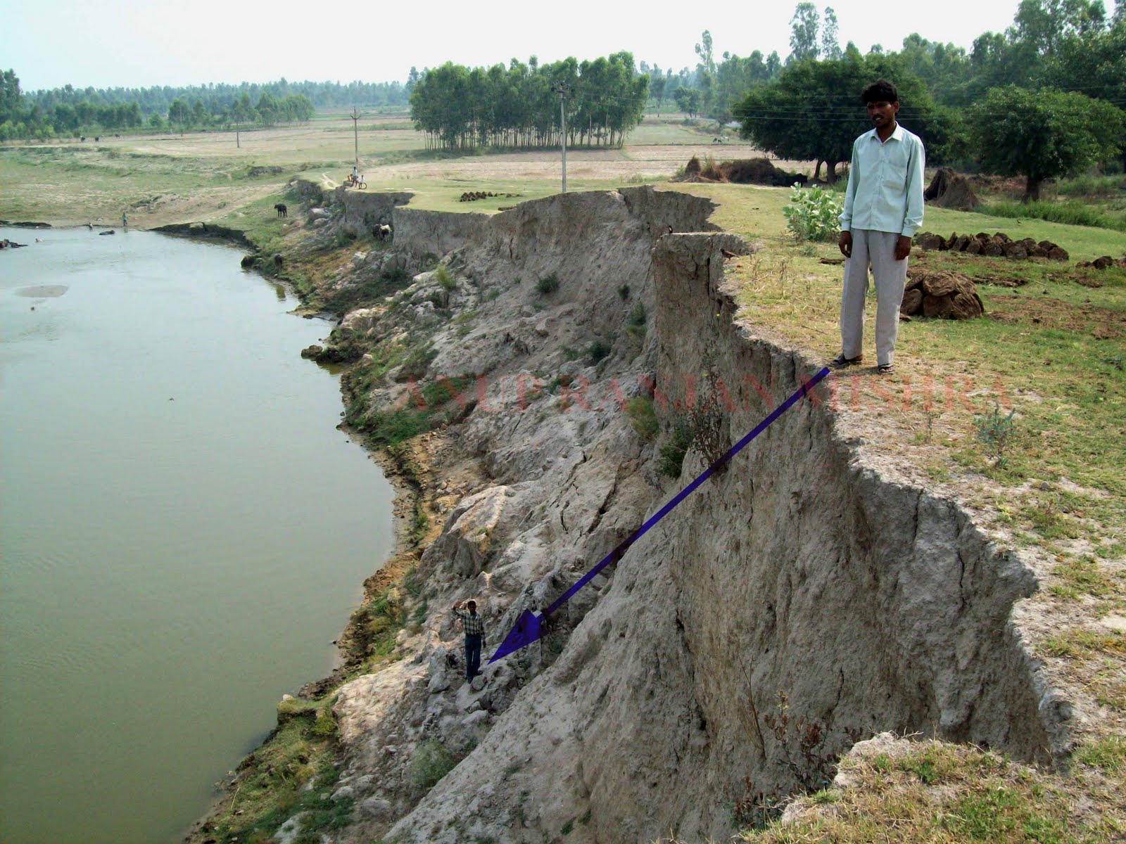
3. Site as a Natural Embankment of the Village, 2011
4.1 Majestic height of the Site, 2011
4.2 Majestic height of the Site, 2011
5. Eroded Section of the Site, 2011

Discovery of the site and its Antiquity

The site was discovered and subsequently reported in IAR by the Department of Ancient History and Culture, M.J.P. Rohilkhand Unviersity, Bareilly. The report says that the site has yielded Kushana and Gupta pottery along with other antiquities and sculptures. A fragmented sculpture of Batuk-Bhairava made of a grey stone belonging to 9th-10th century is noteworthy. The sculpture is displayed in the Panchala museum of the Department. Discovery of another idol of a goddess by the villagers and subsequently its robbery was printed in The Times of India, dated 07th Nov 1987. My repeated visit to the site has brought to light a few potsherds of Painted Grey ware Culture (an early Iron Age culture) on the southeastern part of the mound near the village. This part of the mound is now being cultivated. Finding of PGW pottery has pushed the antiquity of site to 3rd millennium BP.
A few years back, in one of my visits, I had noticed a place of brick robbing near the road side of the mound that looked like a circular foundation of a stupa. There was a pile of wedge-shaped bricks and brickbats. The structure could not be a brick well for its larger size. However, there was no evidence left for me to justify the assumption.

6.Some antiquities given by a villager Mr. Ganesh Misra

7. Brick robbing trench of a large circular structure and the quarried bricks, 2006

8. Burnt brick structure with a window in the section, 2011

9. A circular well peeping out of the section, 2011
10. A burnt brick circular well engulfed by the river, 2011
The Present Condition of Preservation
A metal road cuts the mound in to two halves—northwest and southeast. The modern village occupies the eastern periphery of the site and rest of the southeastern part has been used as agricultural land. There are a few pakad (Ficus virens) and pipal (Ficus religiosa) trees present on the mound on the road side. An adhisthan (chautara or mandapam) of God is made under a pipal tree, which is also used as a sitting or resting place by the villagers. These trees are also used for tethering animals. There are a few abandoned structures present on the mound belonging to a defunct cooperative society. Besides, there is a tube-well present on the road side. 

The mound was like a golf course with a thick grass cover during my first visit in 2002. It was fairly preserved. The river Bahgool that flows directly into the site has been perilous in preservation of the site. Year after year, the river has been cutting down the mound and eroding away in the flood. Large portions of mound collapse into the riverbed during the rainy seasons. In 2005, the mound extended about 71m from the road side to the bank of the river; that was reduced down to about 41m by 2009.  A large portion of the mound was cut away by the river in the flood of 2010. In my last visit after the flood, I noticed burnt brick structure with window and wells constructed of wedge-shaped bricks peeping out of the eroded section. A number of brick wells have already been washed away by the river. One can also notice large dumping pits filled with broken pots in the section. Enormous quantity of broken pots, bones and other antiquities are strewn over the riverbank.

11. The Metal Road running through the site
12. Adhistan and sitting place of the villagers, 2011
13. The River Bahgool flowing directly into the site, 2011

14. Collapsed portion of the mound, 2011
15. Parts of mound rolled down the riverbed
16. Mound parts slided down to the Riverbed
17. Condition of the Site in 2006 and 2011- a comparison

Loss of Bio-diversity
The destruction of site will not only wipe out the villages located in the vicinity but make thousands of birds homeless.


18. Thousands of birds with their nest in the mound section

Who will protect and preserve the ancient sites?
My efforts to draw the attention of authorities have been futile even after repeatedly bringing it to notice and justifying its antiquity and importance in the local news papers. The site has been ignored and left for the natural destruction by the local administration as well as the State Archaeology Department and Archaeological Survey of India. The modern village is small and the people are farmers. “Neither we have money to build a stone revetment nor have a strong vote bank to press the politicians to act for the cause. It is all on the mercy of the almighty to protect us”, quip the villagers.


Big Questions:

Can we (archaeologists and historians) afford to lose such sites?

Can Indian Archaeology progress without such sites?

What will be the future of Archaeology in site-less India?

Think over it................

Urgent Steps Required

1.     Construction of an embankment to protect the site as well as villages from the catastrophic flood

2.     Construction of Speed Breakers or thokkers to arrest the speed of the water

3.     Channelization of the flow of water away from the site

A Pledge…………..
Please ENSURE that all the ANTIQUITIES and DATA including the PHOTOGRAPHS are stored carefully by you or submitted to the Department/Museum to do so. Because, you may be the last person who visited the site and your collected antiquities are the only tangible evidences of that site.
Make sure that you do a bit in your capacity to save a site by reporting in the news papers, writing to the local authorities and placing the matter in different forums/NGOs.

A Request ………..
If you have a similar story, send it to this forum with a few photographs. I also request you to send your comments, grievances and suggestions to this forum which will be circulated widely. Remember that your comment will consolidate our plea.


Mail to…………..

Saturday 10 September 2011

2. AHICHHATRA: At the Mercy of Vandalism

2. AHICHHATRA: At the Mercy of Vandalism


              In the early historic period, North India has witnessed emergence of a number of urban centres particularly in the Ganga-Yamuna doab. Ahicchatra is one of these cities. This is the only major city situated north of the River Ganges. The ruins of the site, popularly known as ‘Pandu Qila’, is located about a kilometre east of village Ramanagar in the Sirauli pargana, Aonla tehsil, district Bareilly, Uttar Pradesh. It is situated about 11km north of Aonla.

The Background

During the age of the Jataka and the Mahabharata, Panchala was divided perpetually into two kingdoms, north and south, with river Ganges as the dividing line. According to the Mahabharata, the Pandavas defeated Drupada, the king of Panchala, in a battle and wrested the northern part of the kingdom and bestowed it to their preceptor Drona. The two kingdoms established their capitals at Ahicchatra and Kampilya respectively. It is said that Raja Adi, an Ahir, who was elevated to the sovereignty by Dronacharya, built the grand old fort at Ahicchatra. Therefore, the fort is also known as ‘Adikot’.
The Chinese pilgrim Hieun Tsang visited Ahicchatra on 15th August 636 A.D. He reached at Ahicchatra by travelling 400 li or about 106 km southeast of Govisana (Kashipur, in Uttarakhand). The capital, according to him, was 17 or 18 li or about 5.6 km in circuit, defended by natural obstacles. In 1861, Alexander Cunningham visited the site of Ahicchatra and on the basis of Hieun Tsang’s account identified it as the capital of north Panchala. 
The country of Panchala attained prominence in the 1st century BC under the Mitra rulers who are known from their coins and inscriptions. Some recently discovered seals, however, reveal that Ahicchatra formed a division (bhukti) of the empire under Guptas. In the 7th century, Hieun Tsang found here 10 Buddhist and nine Brahmanical temples. By the 11th century Ahicchatra ceased to be the capital of Panchala, for an inscription refers to Vadamayuta (modern Badaun, U.P.) as the capital.

Why the site of Ahichhatra is Important?

1.  Presently, Ahichhatra is the biggest, well-preserved, fortified ancient city in India. The perimetre of fortified area spreads over six kilometres and encompasses multiple sprawling mounds, unique terraced temples, samgharas and stupas.
2.  It has a hoary historicity starting from the so-called OCP culture to the medieval period and is a sacred place mentioned in the Brahmanical, Buddhist and Jain literatures.
3.  A mute witness of the mighty rulers “Mitras” who did not figure in the Indian history until the discovery of their coins at Ahichhatra.
4.  "The Ahichhatra School of Terracotta Art" is well-known for its unique artistic expression and style. For example see figurines of Shiva, Parvati, Ganga, Yamuna, etc., housed in National Museum, New Delhi and museums in Mathura, Lucknow and Allahabad.
Bigger the site, lesser we know about it
Sir Leonard Woolley’s report underlined Ahichhatra as an important site that needs attention of archaeologists’ spade. The subsequent excavations in 1940-44 and 1963-65 have brought to light five-fold culture sequence, such as OCP (Pd.I), PGW (Pd.II), NBPW (Pd.III), Kushana and Gupta (Pd.IV). Besides, there are numismatic evidences of rulers of Mitra and Pratihara dynasties. Of late, Agra Circle of ASI has been excavating the site for last three-four years. However, apart from a few isolated publications and researches, per se no excavation report has been published.

The Present Situation

1.     The site is protected by Archaeological Survey of India but not entirely. There are private and state-owned lands present within the fortified area.
2.     Local people cultivate the leased out land inside the fortification enclosure.
3.    Surrounding the fortification wall, there were several mounds, stupas and tanks, many of which have been completely destroyed and some are still partially preserved.
4.    The ruin is a place of livelihood for the people of adjacent villages, who come here for grazing their livestock, agriculture, to work as daily labourer, for collecting firewood, fodder etc., and also work as antique collectors.
5.     While the farmers gradually expand the borders of their land and gradually flatten the mounds, the villagers make tunnels to collect the underlying yellow soil for plastering their mud-floors and walls of houses. These tunnels ultimately lead to the collapsing of the mound surface facilitating theft of antiquities.
6.     The fortification wall is also not spared by these soil diggers. Owing to rapid soil erosion the overlying structures are collapsing down.

 Do we care for it?

 Should we leave the site for such vandalism??

Most Urgent Steps:

*    The erosion of soil and collapsing of fortification walls have to be restricted urgently.

*   The illegal soil digging, transportation of bricks and encroachment of the mounds inside and outside the fortification wall should be stopped and punitive action should be taken against the perpetrators.

*    The entire fortified area and adjacent mounds outside of it should be acquired by the Archaeological Survey of India.

*    The State Government should be pressed for facilitating the transfer of state own land to the ASI. 


Send a comment, Save a site
If you have a similar story, please send it to this forum with a few photographs. We also request you to send your comments, grievances and suggestions to this forum which will be circulated widely. Your participation will strengthen our plea.
Acknowledgements
Sincere thanks to Dr. Pankaj Sharma and Dr. Parth R. Chauhan for providing some photographs. Thanks to the Secretaries of the Society Dr. Neeraj Hari Pandey, Shri Deepak Singh and Shri Anuj Sharma and all the members for their valuable support.

1. Fortification Gate I, 2003
2. Fortification Gate I- 2011
3. Erosion of FF-2002
4. Erosion of FF-2011
5. Erosion of FF-2011
6. Erosion on northern side-2002
7. Furrowing - 2011
8. Furrowing - 2011
9. Collapsing - 2011
10. Remains of RingWell-2011
11. Brick robbing- May 2003
12. Agriculture I - 2011

13. Agriculture II - 2011

14. Agriculture III - 2011

15. Grazing I - 2002
16. Grazing II - 2011
17. Fodder Collection -2011

18. Fire Wood Collection - 2011

19. Shiv Ling - 2002
20. Shiv Ling -2006


21. Shiv Ling - 2010
22. Shiv Ling - 2006


23. Shiv Ling - 2011


24. Shiv Ling - 2012

25. Shiv Ling - 2012

26. Shiv Ling - 2012

27. Broken part of Shiv Ling - 2012

28. Broken part of Shiv Ling - 2012


29. Terraced Temple I - 2002


30. Terraced Temple I - May 2003


31. Terraced Temple I - 2010


32. Terraced Temple II - May 2002

33. Terraced Temple II -Nov 2006


34. Terraced Temple II - 2011 
35. Apsideal Temple and foundation of Stupa, 2004-05
36. Apsideal Temple and foundation of Stupa, 2006-07
37. Shiva T.C.
38. Parvati T.C.
39. Makara Vahini Ganga T.C.
40. Kachhapa vahini Yamuna T.C.
41. Modern Temple within the fortified area